Preface My daughter, Beth, and I had previously done a day hike down the Bright Angel Trail to the 1.5 mile rest stop in late June of 1992. That hike was an afterthought after watching other people hike down the trail. Although that experience was fairly strenuous, the passage of a few years had erased my memories of our struggles that day. This year our family was traveling from Oklahoma to Yosemite and Sequoia National Parks. We decided to stop at the Grand Canyon on the way and hike to the Colorado River. Our plan was for my wife to remain on top while Beth and I hike down the South Kaibab Trail, spend the night at Bright Angel Campground, and hike up the Bright Angel Trail to the south rim the next day. How hard could that be. It is only 7 miles down and 10 miles back up. Beth and I were both active tennis players and in good shape, so this should be no problem at all, even considering I was 53 years old. I had been looking at the Grand Canyon website and knew I had to apply for a permit for overnight camping below the rim. I applied and got my second choice - down to the bottom on May 31, out on June 1. The Canyon website's average forecast temperature of 100+ degrees at the bottom for the high shouldn't be a problem. After all, we are from Oklahoma and its gets hot here too. We spent the night before our hike at the Ten-X National Forest campground on the southeast corner of Tusayan.
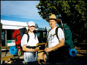
Day 1 We are up at 7:00 and head to the McDonalds in Tusayan for breakfast. After eating we hurry to the shuttle stop by the Yavapai Lodge just in time to catch the next shuttle to Yaki Point. Our food plans are simple: pre-made peanut butter and jelly sandwiches for lunch and dinner that day and for lunch the next day. I have splurged and reserved breakfast for us at Phantom Ranch for the next morning. There is no rain in the forecast, so we won't need to take our tent. Since the temperature is only supposed to get down to 63 degrees tonight at the bottom, we will not need a sleeping bag either, but do decide to take a sweat suit with us. We are taking a thin, blue foam sleeping pad and a fleece bag to sleep in. Without a tent or sleeping bag, our pack weight is less than 25 pounds, so this should be a proverbial "walk in the park."
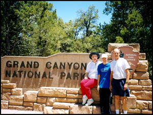
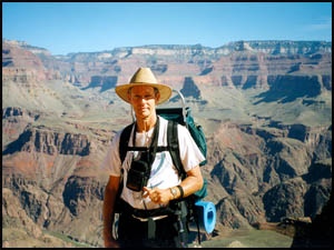
My wife takes our picture by the South Kaibab trailhead just before we start down. It is around 8:30 or 9:00 and the Park Rangers at the trailhead ask us if we really want to start down "that late." I am having difficulty understanding their concern. Well, enough of their silly questions, off we go zipping down the trail at full speed. We pass a number of slow-pokes, who clearly have no business going that slowly on the trail. Since the trail winds its way down the west side of Yaki Point, we will be in the shade until Cedar Ridge and it is actually quite cold. I nearly get out my sweat shirt because I am getting goose bumps. Just before reaching Cedar Ridge, we finally break out into the sunlight. Wow, the temperature immediately jumped fifteen degrees, but it is still a pleasant day for a hike. However, these tennis shoes I am wearing are starting to hurt my toes, but not to worry. I came prepared. I brought four band aides, which surely will be enough for any blisters we might get on this hike. For some reason, my knees are hurting too. A bathroom and water break at Cedar Ridge and we are ready to continue on. By the time we start down and around O'Neill Butte, I am pooped and it is getting warmer. There is a big rock at the end of the first switchback, so Beth and I sit down on it to rest awhile. On the trail behind us, Yaki Point is towering high above where my wife has been waiting. We wonder if she can see us sitting on this rock. We have been talking to one another on our walky-talkies, so we also start looking for each other. In our haste to get to the shuttle stop this morning, my wife forgot to bring her binoculars, and initially is not able to find us. After describing exactly where we are sitting, she eventually locates us and takes our picture with her camera at full zoom. She is equally hard to see at the top of Yaki Point. We finally see her and take her picture at full zoom as well. It has now been over two hours since we started down and my wife is getting tired. We agree to turn off our walky-talkies until tomorrow at noon. My wife heads back to the campground while Beth and I continue down around O'Neill Butte. It sure is dry and dusty on the trail and my toes are really hurting now. As soon as this mule team coming up the trail passes by, I am going to sit down again and tend to those blisters. Anyway my knees are hurting quite a bit also. I use two of my four band aides on blisters. I estimate we have gone two miles since starting with another five miles to go. This is not a good sign of things to come. We finally reach the base of O'Neill Butte on its north side and get a couple to take our picture next to a sheer drop-off overlooking the trail from Indian Garden to Plateau Point. The view is magnificent.
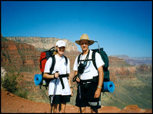
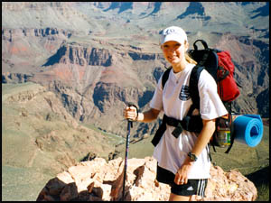
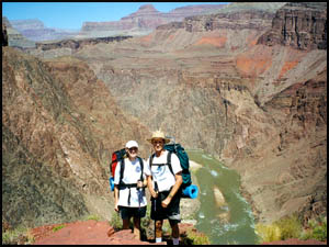
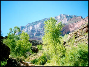
The trail has leveled out somewhat and I limp along until we finally reach Skeleton Point. This is the first time on the South Kaibab Trail that you can see the Colorado River. It is a very striking, green color. Beth and I take turns getting each other's picture, making sure we get the river and the beautiful background scenery in the shot. This has to be one of the most wonderful views in all the Canyon. You can literally see twenty miles or more in any direction. After a few short turns down the trail, though, a series of very steep switchbacks appear that will take us down to the Tonto Platform. The pain level in my knees has now reached about 8 on a scale of 1 to 10. I'm not sure I can get down those switchbacks and if I do, I wonder if I will be able to walk tomorrow. I thought the Canyon website said it was easier going down than up. If that is correct, I am in for even bigger trouble tomorrow. I am now going down the switchbacks one step at a time with a very brief period between steps. Maybe I was a little too quick this morning to criticize those slower people at the start of the trail. After what seems an eternity, we finally reach the base of the switchbacks and start to loop around to the north side of Natural Arch and onto the Tonto Platform. The Tipoff Point and toilet are now in view. It is past noon, so when we do reach the Tipoff Point, we are going to rest and have lunch. There has been absolutely no shade for some time now and it is really hot. I can't believe it has taken us almost four hours to reach the Tipoff Point. Beth and I sit down on the north side of the toilet where there is some shade. I didn't think a peanut butter and jelly sandwich and Gatorade could taste so good. The map shows it is still about two miles from here to the bottom. Lunch is over and it is after 1:00, so we had better be going. I have taken more ibuprofen in hopes of easing my knee pain. After a little farther down the trail, we come to several other points high above the river, all with great views. More pictures are in order.
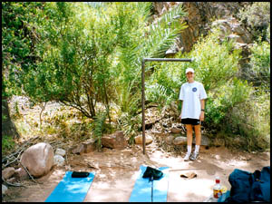
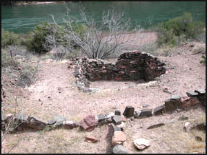
The walls of the Canyon are ablaze in red and orange. The sights are truly majestic. We can see rafters below on the river, but it is still a long ways down. Oh no!! Another unbelievable series of switchbacks have appeared that look worse than those coming down from Skeleton Point. I am definitely in serious trouble with my knee pain now in the 11 or 12 range on that same 1 to 10 scale. The only good thing is that we can now see the Kaibab suspension bridge and tunnel leading to it far below us. I wonder how could they have built that bridge back in 1928, especially considering they had to carry down all their materials. I am still able to inch along on the switchbacks, but only with a great deal of pain. What in the world ever possessed me to do this hike? And I thought it would be fun and easy! What's more, it is stinking hot!! We have finally made it down all the switchbacks and are now going into the small tunnel leading to the Kaibab suspension bridge over the Colorado River. This bridge is pretty neat and an impressive engineering feat. The river is much larger than I thought it would be and is really flowing. Thank goodness we are nearly there as I don't think I can endure much more of this knee pain. The trail on the other side of the bridge is very sandy and a little difficult to walk on. Between the trail and the river are some old Anasazi ruins. I remember from a high school report my daughter did that the small, pit-like structure in the middle of the ruins is called a "Kiva." If it weren't so hot and if I felt better, we might stay and look around a little, but I am really hurting and need to get to the campground. We round the bend by Bright Angel Creek and head north up the trail. I can see the campground on the other side of the creek and can't wait to get there. There is one more large aluminum bridge over the creek to cross and we have finally reached the campground. All the campsites by Bright Angel Creek have been taken, so we select a large site close to the cliffs with a big cottonwood tree to give us what little shade there is. I can't believe how hot it is on May 31st. I can only imagine what the heat must be like later in the summer. That definitely would not be a good time to hike the Canyon. We put our backpacks on the picnic table and, with only a foam pad and fleece bag to set up, our campsite is complete. It is around 3:00, so we have taken about six hours to get to the bottom. Much of that slow pace was due to my extreme knee pain.
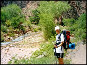
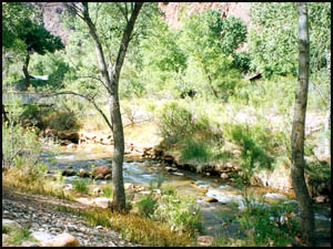
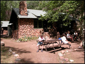
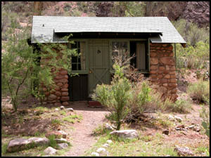
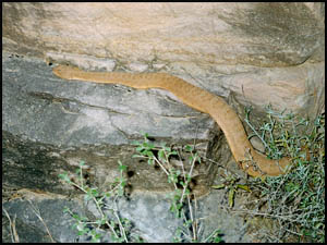
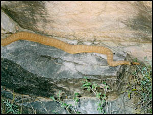
The campground area is surprisingly green. I expected everything to be brown and dead from the heat, but it wasn't. An intricate watering system consisting of numerous little water channels surrounds each campsite. I try napping a little, but there is little shade and the heat is sweltering, so I am not having much success. Beth and I decide to walk over to Phantom Ranch. It is a little farther over there than I thought, but hopefully we can go inside and get cooled down some. There are several little "Hiker's cabins" just before we reach the canteen at Phantom Ranch. The canteen building is old, having been built in the 1920's, and is quite small inside. I assumed there would be air conditioning, but there is only a large water cooler, which is not able to keep up with the heat. The thermometer shows it is 106 degrees outside. At least they offer a few candy bars, lemonade, and iced tea, but no soft drinks. Without a Coke, I am having a caffeine withdrawal attack, so I guess I will have to suffer. Oddly enough, they do offer canned beer. Beth and I have our postcard mailing list with us, so we sit down with some ice water and write out our cards. They have this neat, red rubber stamp: "Mailed by mule at the bottom of the Grand Canyon, Phantom Ranch" that we use to stamp all our postcards. That will surely impress our friends back home when they receive our cards. The canteen has a little saddle bag where you put your postcards to be carried out by mule team the next day. In a while, the canteen employees advise us that we have to leave because they need to get ready for the steak dinner they will be serving soon. Beth and I are envious as we head back to the campground to have our peanut butter and jelly sandwich. When we reach camp, we discover a Park Ranger has given us a "Ticket," actually a note telling us to put our food into the bear-proof boxes and hang our packs on the T-post. The sun has finally gone behind the cliffs and we are now getting some shade at last. I have used the last of my band aides and ibuprofen. Obviously my pre-hike planning was deficient. Fortunately there is a German couple in the campsite next to us that I bum a few band aides from. Nightfall brings slightly cooler temperatures for which we are grateful. By the time we are ready for bed, it has cooled quite a bit. After a few hours, it has gotten fairly cool, so I am glad I have my sweat suit to put on. Day 2 Beth and I are up about 6:00 so we can make it to our 6:30 breakfast time at Phantom Ranch. We get to Phantom Ranch a few minutes early and my knee pain is considerably better today. Hopefully going uphill will be easier on my knees today. Amazingly at exactly 6:30 a girl comes out of the canteen building and announces that we may enter for breakfast. I am impressed. They have the food already on the tables with silverware and plates all in place. We feast on scrambled eggs, the thickest bacon I have ever had, pancakes, peaches, orange juice, toast and coffee. That has to be the best breakfast I have ever had. It was expensive and worth every penny. I hope I can make it up the trail because I am stuffed. After breakfast Beth and I head back to camp and pack our gear. We leave the campground and stop at the rest room near the Colorado River to use the bathroom and fill up on water. I sure wish I had some powdered Gatorade to make the tap water taste better. We are getting back on the trail at about 8:00 and it is already hot. The Silver suspension bridge is considerably more narrow than the Kaibab suspension bridge, so I can see why the mules use the Kaibab bridge. I am surprised to learn that the water line crossing the river under the Silver suspension bridge was only completed around 1970 and that it supplies all the water to the south rim. It is slow going on the River Trail and we take several breaks due to the heat. We finally reach the River rest stop where we take another break. This is the start of the Bright Angel Trail. It goes uphill from this point and follows alongside Garden Creek all the way to Indian Garden. By the time we reach the base of the Devil's Corkscrew, the temperature is well over 90 degrees. The sight of those switchbacks cascading up and into the distance is a daunting one. We start doing about two switchbacks per rest period. I can't imagine doing this stretch later in the summer, later in the day, or while carrying a heavier pack. I am not complaining, though, because my knees have felt reasonably good going uphill. We finally reach the top of the corkscrew section and I have to tell you, I am really tired. The last mile into Indian Garden is very pretty as you are hiking beside a cliff, a creek, and quite a bit of greenery. You are just so tired from the corkscrew section that it is difficult to enjoy the scenery. All of a sudden a loud rattling noise abruptly awakens me from the semi-stupor I am in. I have come within one foot of stepping on a large rattlesnake lying in the middle of the trail. As I leap to the side of the trail, my daughter says she thought I was going to step on it. I quickly get out my camera so I can have proof of my close encounter with the serpent. The trail is so narrow and the snake is so big that I am unable to get far enough away from the snake to capture him in a single picture. Two pictures: a front half and a rear half do the trick.
The excitement makes for a nice break from the grueling uphill climb. A lady who did not speak English came upon us and the snake. She seemed not to comprehend the danger, because she was about to reach out and touch the snake before we stopped her. Time is wasting, so we decide to continue on to Indian Garden. By the time we get there, it must be close to 100 degrees. Beth eats her last peanut butter and jelly sandwich, but I am not hungry right now and decide to save mine until one of the upcoming rest houses. While sitting in the shade, we tank up on water, knowing we are about half-way to the top. Still, it has taken us just over three hours to reach Indian Garden. After our brief break, we are off again and haven't gone too far until we come upon a very tall Century plant. While I am taking a picture of it, I try to get Beth to go out and stand by it. That way we will have something to compare the height of the plant to later. Remembering full well the snake we just saw, she adamantly declines to venture into the brush. While my knees have been doing pretty well, my calves sure are hurting. We were hoping to make the stretch from Indian Garden to the rim in about three hours, but that is not looking good. Just over an hour after leaving Indian Garden, we reach the 3 mile rest stop. I decide to have my peanut butter and jelly sandwich now. I sure wish I had more ibuprofen, but that ran out long ago. And I would die for a Coke right now. After resting about fifteen minutes, we are off again. This section is tougher than the last one. It is steep and the step-ups are big. In just over another hour we reach the 1.5 mile rest stop. The steepness of that last part of the trail and the heat have taken their toll on us. Not only are we pooped, but the stench from our bodies is overwhelming. I feel sorry for the people around us. Of course, they don't look or smell too good either. We have been talking to my wife the last few hours on the walky-talkies. We agree to meet her a quarter mile or so down from the top. Finally, four hours after leaving Indian Garden and seven hours after starting out from the bottom we reach her. She is very relieved that we are back. She just doesn't know how glad we are to be back at the rim. Our calves hurt for a week. While the scenery was breath taking, Beth and I make a solemn promise to each other never to hike the Canyon again. | HIKING INDEX | BACK TO TRIP REPORTS
|